Our hiking group is made up of hikers from Murfreesboro. We started out with picking all the state parks in Tennessee with overnight trails and are taking them on one at a time. This is our story:
Showing posts with label Big South Fork. Show all posts
Friday, November 1, 2019
Big South Fork
Day One: 9.6 Outcasts Total Miles: 2454.6
John Litton Farm Loop 4.2
Duncan Hollow road 0.6
Duncan Hollow Bypass 0.2
Duncan Hollow bike loop 1.7
Duncan Hollow Bypass 1.4
Jack's Ridge Loop 1.2
Laurel Fork Creek 0.3
Day Two: 9.7
Laurel Fork Creek 3.7
Fork Ridge Trail 3.8
Black Horse Branch 2.0
Laurel Fork Creek 0.2
Day Three: 8.5
Laurel Fork Creek 6.6
Slave Falls Loop 1.1
Middle creek loop 0.8
Day Four: 9.6
Middle creek loop 0.8
Fork Ridge road 1.2
Salt Pine Ridge 2.5
Laurel Fork Creek 0.4
Salt Pine Ridge 1.7
West Entrance trail 3.0
Total Miles: 36.6
Troy called out sick for this hike. Since we were planning on doing a part of the Sheltowee and didn't want to have to repeat the trip for Troy, Marco picked some trails in the Big South Fork.
We parked by the pool at Bandy Creek Campground and took the John Litton farm loop. It follows the creek to an old farm where Marco got surprised by a large black snake. When we got to the Duncan Hollow road we took a right and followed it to the Duncan Hollow Bypass road and then did the Duncan Hollow bike trail. This is where the extremely large bear poop. Almost 2" in diameter! Back on the Bypass road we got to hear a Baird Owl calling and then when we got to the trail junction of Jack's Ridge Loop we saw a Momma bear and her four cubs. She stopped and checked us out for a minute and then headed on. We took Jack's Ridge Loop down and crossed the Laurel Creek, for the first of 30 crossings, and took the trail crossing once again before setting up camp for the night. It was a peaceful night around the campfire.
DAY TWO
We got up and headed East towards the big river. We had 4 more crossings today. We got to see a small garter snake just before connecting to the Fork Ridge trail. It is an extremely sharp climb up the ridge before it levels out for a nice walk through the woods. We took the Black Horse Branch trail back to Laurel creek and then took a right on Laurel Creek trail and found a nice campground for the night.
DAY THREE
We got up and got read this morning. We had twenty five river crossing today. We hiked about four miles with crocks on because we crossed so many times. It started a light rain and by lunch we had to have poncho's on. The rain stopped by our last crossing and we climbed up the ridge to the Middle creek trail where we found a spring and stopped for the night. We had a nice campfire again tonight and dried things out. It was a warm night and stayed warm all night. Heavy rain later that night.
DAY FOUR
We got up to the beginning of steady rain that would hang with us most of the day. We packed up and headed to the Fork Ridge road which led us to Salt Pine ridge. We were wondering about the Laurel Creek after all the rain. The one crossing we had today was about a foot higher then yesterday just up to our knees. We crossed and headed up to the West Entrance trail head. The wind had picked up and the temperature was dropping fast. We ended up with the rain coats on and gloves under the poncho. The rain cut out for lunch and mainly it was just water off the trees.
After our celebration at the Waffle House, Marco drove through a small snow fall.
Pictures:
Sunday, February 21, 2016
Kentucky Trail - No Business Creek to Blue Heron
Day One: 13.5 Outcasts Total Miles: 1953.93
Road walk 11
Long Branch, No Business, to Kentucky trail 2.5
Day Two: 7.5
Burkes Branch to Big South Fork river
Day Three: 9.4
Big South Fork to Three West Hollow
Day Four: 1.5
Three West Hollow to Blue Heron Overlook
Total Miles: 31.9
The 22.2 mile Kentucky trail is a beautiful hike through the upper section of the Big South Fork Recreation Area. It runs from the old community of No Business to the Yamacraw bridge. It is labeled on the BSF map and in the 100 Trails of the BSF, but is not labeled anywhere on the actual trail. Mainly they post the next creek or trailhead, but never call it by any other name but "Hiking Trail" on the signs. So you need to know at all times where you are and where you are going.
The trail has three markers: the old red arrow head on the white background, the green square, and a biker marker. Luckily, none are consistent and you don't have to worry about having any of them where you really need markers.
If you are a bike rider and plan on doing this trail on a bike, I make the following suggestions: Get the lightest frame possible, remove the seat as you won't be using it, remove the tires as you will break them, remove peddles and chains since you don't have tires, get a good piece of webbing and strap it to your back. You will be carrying the bike more than riding the bike!
Now for the Outcasts, anyone can do this trail in good weather. I suggest late fall, winter, and early spring since I am sure this trail grows over rather fast. As for us, we wait until a good freezing rain and snow before we head out.
When we get to Blue Heron we are met with a barricade, a ranger, and snow plow. We tell him of our plan to hike the Kentucky trail and we need to leave a car. Of course he is not familiar with the Kentucky trail and there is no way we can go to the Blue Heron parking area because of trees and ice on the road. He said that we could park at the Overlook if we can make it up there. So this is what we do. What is one extra mile?
By the time we get back to the lower part of the park it is pouring down freezing rain and the road is getting slick. Divide road, which we need to take to Terry Cemetery is covered with ice and snow. We head to Pickett State Park and rented a cabin. The Ranger there has never heard of the Kentucky trail, but knows where Terry Cemetery is. We have to hike to No Business Creek to start the trail. Rain turns to snow.
The next morning we head out and get a few hundred yards down Divide road before we get stuck. We back out to the main road and think, and think, and think....
Heading back towards Pickett we found a ranger at the Forestry garage and stop. We tell him that we cannot make it down Divide road and need to find a place to park. He has not heard of the Kentucky trail but knew where Terry Cemetery was and Blue Heron was. He said that four wheel drive vehicles cannot make it down Divide road when it is like this. He let us park by the fire tower, but wasn't really sure that he would ever see us again. What is adding 11 miles to the hike?
So we hike down 154 to Divide road to Terry Cemetery road to Long Branch trail. It didn't take long to find out what an ice storm does to Hemlock trees. For every Hemlock standing, there were three across the trail. Only for the entire hike we went over, under, through and around trees. Our first foot washing, shins, knees, thighs was the No Business Creek. It had quite a bit of current as well. After three foot washings, we came to our first bridge at Dry Branch. This is where the Kentucky trail begins. They had signs everywhere for everything except the Kentucky trail. Made us feel good right off. Anyways, we set up camp for the night. We got to hear owls and coyotes during the night. When Marco and I hung the bear bag, we ended up with a branch on top of us. Must be too much food. Had to find another branch.
Day Two:
More trees down. It really slowed us down and gave us an over all body workout. We were really amazed by the bike trail markers as you could not ride a bike even without the storm damage.
When we got to Difficulty Creek a tree was down across the bridge which required another foot washing. This became our running joke as trees were down on all bridges after this and on everything else.
When we got to Troublesome Creek we found that these creeks are kind of depressing just by name alone. Troublesome Creek bridge had a hole through it about the size of a horse.
When we got to the Big South Fork River, we found us a spot to set up camp for the night. We watched the sunset over the river and settled into a night of telling lies and taking cough medicine. After Troy had gone to bed, Marco and I heard a loud cracking sound like a limb falling off a large tree and then a yell. We headed over to check out the damage, when we found Troy laying under his tarp on the ground. The tree that he had tied his hammock off to had fallen over. I don't know how, but it fell sideways instead of on top of him and fell along side my hammock without damaging anything. After making sure he was OK, the laughter began. We helped him get set up again before going back to the campfire. Troy wasn't scared, he was back asleep within minutes.
Day Three:
This morning we hiked down the river. If the river had been up to flood stage this trail would be impassible. We could see where it had gotten up to the last time and it was still muddy from that. When we got to the trail to go up out of the river valley, it to was covered in downed trees.
The area around Ledbetter Trailhead was gravel roads with trees across it. Not much as far as markings, but referred us to the "Hiking Trail".
I went to check out the Big Spring Falls as Troy and Marco cleared the trees off the Big Spring Hollow bridge. From here the trail follows the old Tram bed all the way to the bridge of Blue Heron. You get off it long enough to see Dick Gap falls and the Catawba Overlook. We set up camp on a level area above the trail for the night.
Day Four:
Just before you get to the Mine 18 tipple bridge you start finding parts of old mining carts. We crossed the bridge and headed through the "Cracks in the Rocks" which is just like it sounds. They have stairs where you go over fallen boulders. We climbed up to the Blue Heron overlook and then headed back to the car.
Pictures:
Labels:
Big South Fork,
Craig,
Kentucky Trail,
Marco,
Troy
Tuesday, November 18, 2014
Big Island Loop - Big South Fork
Pilot Wine Loop 1.6 miles Outcasts Total Miles: 1736.08
Big Island Loop 16
Pilot Wine Loop 1.6
Total Miles: 19.2
For some reason the weather changed and there was a great Northern freeze moving in. As usual the closer we got to Big South Fork the more snow was falling. It started building up on the ground. We stopped by the Hitching Post to pick up a camping permit. The man there said that the park had come in when the government shut down like the Nazis and confiscated all their permits and records. We said OK and headed to the park headquarters. The Ranger had put all the permits away for the year because of the weather, so he had to go to another building to get them. I told him that we had tried to get one at the store and he said that they pulled them from some stores.
The ranger then started teaching us about picking out trails after we convinced him that we were not here to hunt. "Well you guys are the second third and fourth person to stop by. The first one bought ice." He showed us a lot of trails that he likes to recommend. Most of them we had done, but he did teach us about downfalls. There is a "Bear" downfall and a "Giant Oak" downfall. If you come across a downfall and I don't mean a tree that a bear dragged across the trail, but a giant Oak that you cannot get around or over, call him and he will get it on the list to be removed. After all these years, we are still learning.
To the trailhead we went. Different than the last two times in Big South Fork, we didn't start in a major snow storm this time. The temperature was dropping and it didn't take us long to get an old fashion foot washing in. The water was up all over so we dropped the shoes and did a little barefoot wading.
This is a horse trail, but we knew we didn't have to worry about seeing any hawses on the trail today. We were told that after it drops down to freezing they have to put those animals in the barn. It does make it challenging to hike on frozen hoof prints in the mud.
This trail drops off into the river gorge and you walk along the Big South Fork river. There is an Indian "Dome" rock house, a old Ford car upside down, and an old cabin on the trail to check out.
We found a place to make camp along the river out of the wind. The temps dropped down to 17 degrees, but Troy kept the fire up to around 70 degrees. We had a good evening telling lies and taking cough meds. Sometime in the night another inch of snow dropped on us.
Troy woke up to a loud "thud". He thought he heard some grumbling and then another "thud". He asked Marco if everything was alright and heard more grumbling. He asked again with the same result and then screamed "Marco are you all right?" More grumbling so he got up and yelled "Marco are you all right?" This is when I woke up too. Marco yelled back "I fell out of my hammock!..... Twice! And couldn't get out of the bug netting." Lot's of laughs.
The next day we got to see the car and cabin. They had built an outhouse at the cabin since the last time we were here. It's a two holer which would make any man proud! We though about crossing the big river at the two crossings we came to just for practice, but then decided against it.
Another good hike! When I called to let Lora know we were off the trail, she said that they had closed all the schools in the area for the last two days due to the weather. We apologize to all the parents out there.
Pictures:
Labels:
Big Island Loop,
Big South Fork,
Craig,
Marco,
Troy
Wednesday, March 26, 2014
Pilot Wine Loop
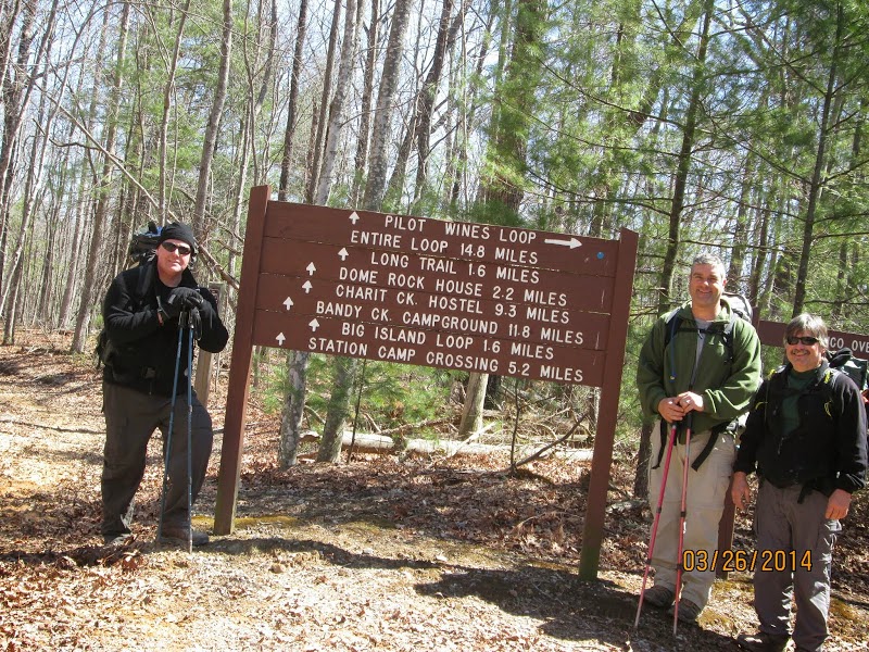
Pilot Wine Loop: 14.8 miles Outcasts Total Miles: 1659.68
We had us a weather full hike this time. We headed to Big South Fork in the snow. We started at the Station Camp East trailhead and did the loop counter clockwise. This is a horse trail following an old roadbed all the way around.
Pilot Rock is actually just off the trail and you have to some bush whacking to get to it. After you drop down through some very pretty rock walls and go around them there is a small campsite. From that campsite if you continue straight out when the trails turns right and down you will find Pilot Rock.
We continued down to the river and camped along side the Puncheoncamp Fork of Williams Creek right at the confluence of Grassy Fork.
While we were hiking we had about five different white outs with sunshine in between. When we got to camp, the snow was so big of flakes that you could feel them hit you. We got about an inch on the ground before it stopped and we gathered fire wood during this time. When it stopped, we set up camp and within a half hour the sun had melted it all away. This is Tennessee.
Just before we got to camp we saw a flock of turkeys. We had ducks on the creek and listened to an owl while we were setting up camp.
We enjoyed an evening around the fire telling lies and taking cough medicine. It got down around 15 degrees that night.
The next morning we headed out and finished the loop with plenty of sunshine. We saw a ground hog on the way out of the park cross the road in front of us.
Eye will see you next season!
Pictures:
Labels:
Big South Fork,
Craig,
Marco,
Pilot Wine Loop,
Troy
Friday, January 24, 2014
Big South Fork Cumberland Loop
Day One: 8.3 Outcast Total Miles: 1599.48
West Entrance Trail 3.4
297 Road 1.0
Trailhead 0.2
Gernt Trail 3.3
Overlook .4
Day Two: 14.1
O&W Trail 5.5
Tar Kiln Trail 4.5
Darrow Ridge 3.2
Christian Cemetery 0.5
Panther Branch Trail 0.4
Day Three: 9.6
Panther Branch Trail 0.5
Little Cliff Trail 1.5
O&W Trail 5.2
Coyle Branch Trail 2.1
North White Oak 0.25
Day Four: 3.3
North White Oak Loop
Total Miles: 35.3
Once again the weather saw us coming. It started snowing on our way to Big South Fork. We kinda caught the ranger by surprise as he was not expecting any hikers today with the snow and 31 degree forecast. Our high was supposed to be 31 this hike with a low of 4. We were close as the high was 16 and the low was -5.
We got our permit and started at the Bandy Creek trailhead with a heavy snow falling. We hiked to the West Entrance Trailhead on 297 and then did a road walk to the Cumberland Valley trailhead. We had a couple of white outs on the way. The West Entrance Trail is very beautiful.
We then hiked the Gernt Trail down to the Laurel Fork Overlook. It was very nice with all the snow. We continued our hike to the O&W trail along the North White Oak Creek. We stopped at the Laurel Fork Ford to size it up for the next morning, then camped along side it on an old road bed. We collect our wood, set up camp and enjoyed the evening. The temp dropped to -4.
Day Two
Well, the Laurel Fork Ford had frozen over during the night so we had to break our way across it. We did get some scratches from the thin ice and it took a little quarter mile walk to get the feet heated back up. Not bad after the pain was gone. The O&W trail is an old rail bed along the North White Oak Creek. There was lots of icicles, frozen ground, and frozen water along the trail. We saw lots of fresh coyote tracks in the snow. Our next fording was of the Panther Branch Creek. Not as much ice on this one. Less pain. We stopped and ate lunch along the side of the trail later in the afternoon.
At Tar Kiln trail we headed up and out of the river gorge and followed an old road bed through the woods. It really would have been muddy if it was not frozen over. There were lots of tracks in the snow. Deer, cat, rabbit, and coyote tracks all through this area. We got on the Darrow Ridge trail which is a dirt road and followed it to the Christian Cemetery Trail. When we got on Panther Branch trail we started looking for the creek as the ranger had said it would be "difficult to find." Well much to our surprise, we found it under the first bridge we crossed. We got a laugh about it and then set up camp in the woods near by. It was another good night by the fire as the temps dropped down to 7 degrees.
Day Three:
We did the ritual of thawing out water the next morning, packed up, and headed out. We finished out Panther Branch and then took Little Cliff Trail back down into the river gorge to the O&W. We though about going back and crossing the Panther Branch again just because that is what Outcast do, but just continued our trip. The North White Oak Creek had frozen completely over in some places now and when we got to our Laurel Creek fording, it had frozen over too.
The ice was about an inch and a half thick. Marco made it about halfway before he broke through and actually got back up on the ice part of the way across before breaking through again to finish the crossing. I told Troy that we did not stand a chance, being as we both weigh more than Marco. So it was in and out and in and out for us as we crossed as well. Marco was the only one to get a good cut on his leg from the ice so we fared quite well.
Shortly there after we had a fording of the Groom Branch. As I was putting my socks back on I told the guys, we probably need to wash our sock along with our feet at the next one. Then we got some miles in to warm up. We stopped and ate lunch along the trail. My tuna salad sandwich was frozen solid. It still tasted good. Today's high was 16 degrees and it got cool when the wind blew.
Our next fording was of Coyle Branch before we headed up out of the river gorge on the Coyle Branch trail. This was all a very pretty part of the park. The top part of the trail is road and we got off on the White Oak trail to find water for the night.
We found water on the Coyle Branch and made camp in a swampy, but frozen area. We did have some problem with the wood being frozen and slow to burn, but we managed to stay warm as the temps dropped to -5. We found that at a damp -5 we have to add clothes to our sleeping gear so that is our bag and hammock limit. We listened to the owls talking that night. It is difficult to go potty when you are shaking.
Day Four:
All of our hammock screens, tops of our sleeping bags, and underside of our tarps were frozen this morning. Well, for that case if you stood around very long your breath started piling up at your feet. We got a good hot fire going to thaw our water out to make breakfast. We had 3.3 miles back to where we parked our cars and one fording of Bandy Creek. Kept the long underwear on today.
After we got back, we stopped by the ranger station to let them know we were done. The ranger asked if we really did all of our trail and we told him about our adventures. He had been writing down the temps for us and said that we had "bragging rights." We let him know we earned those along time ago. A couple of other rangers came in and wanted to hear our story as well. I don't know why they just can't believe someone would backpack in this weather.
Pictures:
Wednesday, December 18, 2013
Gobblers Knob
DAY ONE:6.8 Outcasts Total Miles: 1546.58
Gobbler's Knob Trail 0.8 Miles
Hatfield Ridge Trail 0.9
Hatfield Ridge Loop 1.0
Twin Arches Loop 3.1
Slave Falls to Charit Creek Trail 1.0
DAY TWO:13.5
Slave Falls to Charit Creek Trail 2.6
Slave Falls Overlook Trail 0.4
Slave Falls Loop Trail 1.1
Middle Creek Nature Loop 1.8
Fork Ridge Road 0.8
Gobbler's Knob Trail 6.4
TOTAL MILES: 20.3
Travis joined us once again. We headed back to Big South Fork to take in some more wonders of the world. There is so many things to see in this one park that it is amazing.
We headed out and were on the trail by lunch. We started at Gobbler's Knob trailhead and did a loop clockwise. Our first place to see was the Charit Creek Lodge. A place that you can hike or ride a horse to and stay the night. It is very pretty and rustic with no electricity.
We then headed to the Twin Arches which is a very popular site in the park. The North Arch has a clearance of 51 feet, a span of 93 feet and its deck is 62 feet high. The South Arch has a clearance of 70 feet, a span of 135 feet and its deck is 103 feet high. We got to spend some time exploring the area and rock features around these arches as well as take the stairs up to the top of the arches and enjoy the view especially from the top of the North arch.
From here we continued to Jakes place where they keep a cleared field and the rocks from the chimney of the original house which has been moved to the Charit Creek Lodge grounds. We passed many rock houses and walls. We then headed toward Slave Falls and camped along the creek for the night.
Travis slung straight into building us a rock fire ring which turned out quite impressive. He had a fire going by the time Marco and I got our hammocks up. We had a very nice evening enjoying the stars along with some lies and cough medicine around the fire. We had a full moon which lit up the woods all through the night.
The next morning we headed up to the 60 foot Slave Falls. There are two trails each 0.2 miles long from either side of the falls. In between we got to see Needle Arch, a narrow band of sandstone 10 feet high and 30 feet wide that resembles the eye of a needle.
We incorporated the Middle Creek nature loop trail into our hike which added a couple of more miles in for our viewing pleasure.
Once again we really enjoy the Big South Fork and all that it has to offer.
Pictures:
Labels:
Big South Fork,
Craig,
Gobblers Knob,
Marco,
Slave Falls,
Travis,
Twin Arches
Monday, November 16, 2009
Sheltowee Trace Part I
Trail……………Rating…………Miles…………………….Outcasts Total: 686.0
Day One:
Rock Creek Loop…..Easy…..…..2.25
Sheltowee Trace…….Easy…..….4.35
Total……………………………..6.6
Day Two:
Sheltowee Trace…….Moderate….6.44
Gobblers Arch……..Difficult….…3.86
Total……………………………..10.3
Day Three:
Sheltowee Trace…….Moderate…11
Day Four:
Sheltowee Trace……Moderate….10.9
Day Five:
Sheltowee Trace……Moderate…..5.8
Total……………………………..44.6 Miles
We knew that something was wrong when we actually slept through the night at work. What were the chances that on a planned five-day hike that a hurricane would come to Tennessee? We got up and headed to Big South Fork in the rain.
Greg, Chase, Troy, Shadow, Marco, and I were going to start the Sheltowee Trace. It is a 260-mile trail that runs from the Big South Fork to Northern Kentucky through the Daniel Boone National Forest. We had hiked the first 9.4 miles when we hiked the John Muir trail last season, so we started where we left off and took the Rock Creek Loop trail to get where we needed to start.
Troy, Marco, and I came in one car and signed us all in. Greg got caught up in traffic on I-24 so we didn’t get started until 1pm. We also did a little extra off road driving getting to the trailhead just for practice. You know the Outcast way.
The rain stayed steady as we made our way to Kentucky. This made the trail slick and added the challenge that we always like. Chase and his dad took turns trying to outdo the other with trips and falls. Chase ended up on his back one time. There was one section of trail that was completely washed out and we lost Chase and Troy to slipping and sliding. Then as Greg was attempting to cross a downed tree, he did a fancy dance which one step took out Marco’s hiking pole. He managed to stay up, but the pole was totaled.
The rain did stop by the time we got to our first stop at Great Meadow campground. We forded the river to get to it. We set up camp and Chase actually got a fire going. Some stories were told and cough medicine taken.
The fun started at bear bag hanging time. Greg, Marco, and I gathered all the food and headed to a large tree. The target was a four-inch in diameter branch about fifteen feet off the ground. After a couple of attempts we got the makeshift rope over the branch and attached the bag. The one section of rope was stretching and not sliding over the branch.. It didn’t help that we were trying to lift about two hundred pounds of food. We swapped out some rope and tried again. We finally got our food bags up where we wanted when snap…………….the whole branch broke off the tree. Well, this kinda hit my funny bone a little. The other two started laughing at me laughing and this dragged out for quite a while before we could regroup. Plan B. We found a limb on the other side and took a vote on if this branch was alive or dead. We had to use the branch that broke off to help lift the massive amount of food into the tree. We smiled with joy about the same time that the rope broke. Plan C. We used two ropes and two bear bags and life was good.
The stars came out and we had a beautiful night. Some time in the night the hurricane passed through. I woke up to the flapping of my tarp wondering what was going on. The next morning we collected the articles that had blown away in the night.
Day two started out with a ford across the river. It’s a good way to start the day and get everyone going. We hiked down to where the Gobblers Arch trail intersects. A vote was taken. The Sheltowee crosses Mark Branch numerous times. Troy said about 17 times or we could take Gobblers Arch, which is the high water route. It is described as the driest, but most difficult alternative. I got out voted so up we go. When you got to the base you could look straight up the mountainside and that was your trail. No switchbacks for the half-mile climb. Then you got a short brake before you started going up hill. It added a mile and a half to our hike and kicked some butt. We took a lunch break at Gobblers Arch.
Once we got on Divide road, we hiked the rest of the day on the road. We got our water from the Punchencamp Branch where we saw our first hunter in the woods next to a couple of caves off the North side of the road. We stopped for the night at a large rock shelter with a pool beneath it. It had been used as a campsite before.
We listened to an owl talk as we set up camp and made dinner. After the stories were told and meds taken, the bear bags were hung and everyone hit the sack. I stayed up by the fire and listened to the wildlife. It started with the frogs. They all talked at once then they all stopped about fifteen minutes later. Then the bats took off. I thought that they would come through camp and crap on me, but I just heard them all flapping at once with the high pitch squeaking. After that the birds came through camp. Not sure what they were, but they were perking like Turkeys do. After all that excitement, I went to bed.
Day three; we got off the road. A little while after the initial climb, Greg just hit his knees in the middle of the trail. We assumed that it was time to pray, but we found out that he just fell over a hole in the trail. Then while on break Marco took a picture of Troy and the truth was caught on film. You could actually see Troy’s pack refilling with the lightweight fairy dust that we had all heard about. Lots of climbing today until we finally reached the top with a rock climb and wonderful view.
After we reached the top and ripped our shins on the thorn bushes, we started down. We did some more road hiking and then headed on down to Grassy Creek where we did a little bathing and airing out of the tents and hammocks.
After the break we headed back up the mountain to go back down the mountain and after many creek crossings we went on to the crossing of Big Creek. We got some pictures of Troy carrying Shadow across the creek. The trail then climbs up to and we cross the Yamacraw Bridge. We camped just on the other side of the bridge at a campsite by the Big South Fork Cumberland River.
Greg made connections to get picked up here in the morning. His back was acting up and he had a serous foot injury that let him know that it was time to call it quits. Luckily it happened by a good road and easy to find location.
Stories where told and cough medicine taken by the fire. At bear bag time Chase headed out to a tree to hang their bag. Shortly after he left, we heard some screaming and hollering going on. We all ran to see what had happened to Chase, when in his light beam you could see two sets of eyes bouncing down the trail toward him. What the ___? When they finally came into the light of the other headlamps, you could see that they were two dogs and with the screaming had finally pulled of course and headed through the woods. That was exciting. A short time later we saw some lights up on the hillside and knew that they must have brought the dogs. The people never came down or hollered at us. The lights disappeared and later we could hear the dogs barking up by the parking area. Chase and I made a night hike to check things out and everyone was gone.
More cough medicine was needed. You could have used Chase to mix up drinks with all the shaking he was doing. Finally one by one everyone headed to bed.
Day four; we said our good byes to Greg and Chase and headed down the trail. We hit all the mile markers Lick Creek, Negro Creek, Cotton Creek, and Alum Ford. There is a large flat campsite just past Negro Creek. A shelter, which is not on any map, past Cotton Creek. Alum Ford is a regular campground with roads. We stopped here for lunch and hung everything out to dry. We saw two different deer during this section of the hike.
From Alum Ford we hiked on to Yahoo Falls. The actual fall was not impressive, but the rock formations were. After you hike out of the cove back to the Cumberland there is an outhouse and a flat area by the river to make camp. After this the trail doesn't have any water on it and you cannot get to the river until Big Creek. The trail is rugged in this area and the first camping spot with water is on Big Creek in a rhododendron patch. Here, there was just enough room for the two hammocks and a tent if you have a campfire.
We celebrated our last night out with an overdose of cough medicine. Marco was buzzing. I told the guys that there was good news and bad news. The bad news being that we were at an isolated part of the park, we might see a bear. The good news being that we probably won't hear it because of the river. They felt alot better after I told them that.
We got up the next morning and headed out. There were alot of water crossings and the trail was mostly uphill. We climbed uphill to the swamp and then climbed uphill after that. The area at the start of Big Creek is a waterfall that you hike behind. It is a very beautiful area with the rock formations, but we had some major tree falls in the trail. From here we hiked to 27 where we got to wait for a train before we could cross the tracks. You hike between the church and daycare up the road to get back into the woods. My folks picked us up at the 27 trailhead with some homemade apple pies. Life is good.
Pictures:
Labels:
Big South Fork,
Craig,
Greg,
Marco,
Sheltowee Trace,
Troy
Wednesday, September 30, 2009
Honey Creek Loop, TTA Hike
Day One:
John Muir 2.3....Easy
John Muir 1.8....Easy
Leatherwood Ford Loop 3.1....Easy
River Overlook 0.2....Easy
Total: 7.4 Miles
Day Two:
Honey Creek Loop 5.6....Difficult
Honey Creek Overlook 0.2..Difficult
John Muir 5.0....Easy
Burnt Mill Bridge Loop 1.4...Easy
Total: 12.2 Miles
Total Miles: 19.6 Miles
This was a Tennessee Trails Association hike that Marco and I went on. We are both members of TTA and we joined Millette and Lora of the TTA.
Plan A: Sara planned this hike as hiking the Honey Creek loop and car camping Saturday night.
Plan B: I suggested we hike Sunday as well and do the John Muir trail. Sara agreed.
Plan C: Sara broke her ankle so Millette was the hike leader and due to rain planned to go the campground Saturday night and hike the Honey Creek loop Sunday.
Plan D: We headed out Saturday morning in the rain and this is how it went:
Because the rain was more of a down pour, we all met up at the Bandy Creek Visitor Center. After a doing a little visiting we decided to hike in the rain as it had changed from a down pour to a light rain. We decided to go for a safe rain hiking trail and picked the John Muir out of Leatherwood Ford to the O&W Bridge. As it turned out with all of the water falls, it was a beautiful hike. There were water crossings and they were quite high as the rain built them up. We found a nice overhang to eat lunch under. It cleared up a bit by the time we got to the O&W Bridge and we got some beautiful views.
On the way back, we decided to take the Leatherwood Ford Loop up to the River Overlook and back to Leatherwood Ford. We were already wet and there was still day light. Millette showed us a few fancy steps today, but nothing like Sunday.
We camped at the Bandy Creek campground, where the girls set up in one site and the boys in the other. We enjoyed some chicken, with Lora's family secret sauce, and tator's. Life was good. We followed up with some marsh mellows over the campfire. Cough medicine was taken and some stories were told.
The rain decided to show up again after I went through all the work of getting the moon and stars to shine. We decided to have a tarp party. We all sat in a row with a tarp over us as we watched the last of our campfire being put out by the rain. The last thing was the car camping as we sat and listened to CD's as the rain came down. Finally we decided to call it a night.
The next morning we got up, had a warm breakfast and headed to the trailhead. Millette was going to do the Honey Creek loop no matter if the water was over our heads. We dropped a car at Burnt Mill Bridge and headed to the Honey Creek trailhead.
Now Millette showed us some moves yesterday, but she was dancing with the stars today. Marco, who was not to be outdone, did a 360 on the trail that was quite stunning. So, I had to show them how to hit the trail and I did a good job.
The trail was challenging with the high water and wet rocks. The water crossings were deep and took a little talent. The trail led us astray a couple of times with inadequate marking. The lizzards were out and even a couple of snakes. The waterfalls were beautiful and we got some wonderful views from the Honey Creek Overlook where we ate lunch.
After the loop we took the John Muir trail to the Burnt Mill loop to Burnt Mill Bridge. The John Muir trial was mostly old road bed until we got to the river. At one point when I was leading, I came upon a large rat snake that not only surprised me, but decided to challenge me as well. He had a little attitude. I turned to Lora who was behind me, but had levitated about three feet off the ground and passed everyone to the back of the line.
We finished up the hike with a good long and deep water crossing where the river had flooded the trail.
We got another surprise when we got back to the truck, as we found that we had gotten into a nest of seed ticks which ate us all up.
It was a great hike. Sorry that Sara couldn't make it, but she was with us in all of our minds.
Pictures:
Labels:
Big South Fork,
Burnt Mill Bridge,
Craig,
Honey Creek,
John Muir,
Leatherwood Ford,
Marco
Sunday, March 22, 2009
Angel Falls Trail, River Trail East, Big Island, and Pilot-wines loops
Trail.....................Miles..........Rating.........Outcast Total: 548.7
Day One: 8.1
Angel Falls Trail.....2 Miles.......Easy
River Trail East......6.1 Miles.....Easy
Day Two: 15.3
Station Camp..........0.2 Miles.....Easy
Big Island Loop Trail...5 Miles.....Moderate
Indian Dome Rockhouse...0.4 Miles...Easy
Pilot-Wines Loop Trail..9.7 Miles...Moderate
Day Three: 14.2
Pilot-Wines Loop Trail..3.1 Miles....Moderate
Big Island Loop Trail....9 Miles.....Moderate
Station Camp...........0.1 Miles.....Easy
River Trail East.........2 Miles.....Easy
Day Four: 6.1
River Trail East.........4.1.........Easy
Angel Falls Trail.........2 Miles.....Easy
Total Miles......43.7
We didn't mean to out run the horses!
Troy and I were the only ones that could make this hike. We headed out after work and made our way, after signing in, to Leatherwood Ford Trail head parking. We got on the trail at noon. We used 100 Trails of the Big South Fork by Russ Manning for our trail description. There is a lack of signs on these trails, but they do use metal trail markers which are few and far between. Red for the Loop trails and red and green for the river trail.
Angels falls trail is an easy hiking trail running along the Big South Fork Cumberland River to Angel Falls. River Trail East connects Angel Falls with Station Camp crossing. We did have two creek crossings that required the donning of the old Crocks. The weather was beautiful and it only called for rain on our second day. The sun was shining, the birds were singing, and the ticks were after us. Yes, there were plenty of ticks on this hike.
That evening as we started looking for a camp site, we walked into Station Camp Crossing. There are a few camping sites here and Station Camp Road ends here. It was 5pm and we were ready to eat.
We set up camp, collected fire wood, got our water, and settled in for the night. It was only suppose to get down to the mid forties tonight. The owls were out tonight and a friendly coyote called in the night. About the time we got ready to call it a night, here comes the truck. It was a few young kids out having some fun. Luckily they didn't stay long and we got to bed around 11pm.
We got up the next morning and no rain. Yes, things were looking good. We only had a coyote visit during the night and he just headed right through camp. I got some pictures of the Station Camp Crossing which you can only cross the river during dry weather. At 8:15am we headed across the parking area and started the 600 foot climb into the hills on the Big Island Loop.
We made it to the Indian Dome Rock house around 11am. It is basically a cave like opening with a big room that has a dome shaped ceiling. Pretty cool to check out. We hiked an hour longer, got on the Pilot-Wines Loop trail and did lunch at a creek crossing. This is when we hung out our stuff to air out and also where I left my clothes line.
I went to the creek, found a deep spot to fill my bucket, leaned against a tree and reached out only to notice that I got no resistance from the tree and it followed me into the creek. I looked like a cat heading into a bath tub. I was reaching and scratching for anything that I could get a hold of. I managed to get only minor wetness of the foot during this episode.
As we finished lunch, a light mist began to fall. We packed up, put on the old poncho and headed out. The mist didn't last long and we had a beautiful day to hike.
We stopped at the Station Camp Horse Camp Trail head parking area. It is a very large gravel parking area which would make a good spot to park if you were hiking the Big Island Loop or the Pilot-Wines Loop for a day hike or overnighter.
After we left there, we came upon the Wilderness Resort, which we found out later was privately owned and operated, but has access to the Pilot-Wines Loop trail. It looks like some fancy log cabins and a large horse stable. For hikers there is a water source at the barn.
The last source for water before Pilot Rock is a creek that runs along a rock bluff just past the private land. We got lucky and found some water right at Pilot Rock and spent the night at the camp there. We ended up hiking 15.3 miles by the time we found the water source to camp by. We must have looked pretty bad because the vultures were circling us when we made camp at 4:30pm. Did I mention that the ticks were out?
There was ice on the water buckets the next morning. We had slept in an extra hour so we got on the trail at 9am. After Pilot Rock the trail drops 600 foot to the Grassy Branch which we got to try out the old Crocks again to cross. After crossing the river we did the 600 foot climb back out to join the Big Island Loop again.
We dropped the 600 foot to the the Big Island crossing and stopped for lunch. We aired out the packs and rinsed out some clothes. Big Island crossing is one of those river crossings that you can only do during low water. While we were eating three horse riders rode by. We saw them again at the cabin which is at the first river past the Big Island crossing.
The cabin is a good place to stop if you can work it into your hike. It has two bedrooms and a loft for sleeping. There is a big fire place and a picnic table inside the front room.
We left our horse riders and headed down the trail. They caught back up to us after going back and finding a lost jacket. They were surprised on how far we had made it. They said that we were more like trail runners than hikers. Well, we really impressed them when we came hiking into Station Camp crossing and they were there taking a break. I wished that I would have known that we were going to catch up to them. We would have picked up a couple of old beer cans and walked in drinking beer. Their reaction was "Holy Sh_t, I'm going to have to get a set of those hiking poles" when we walked up on them. They asked how much further we had to go and I told them that we had 8.1 miles to the truck, but only had an hour to get there before dark. You should have seen their faces then.
To avoid any more visitors we hiked down the River Trail East for a couple of miles before setting up camp. We got in a total of 14.2 miles by 5:30pm. We found some ticks and listened to owls as we sat around the fire.
We got up in the morning and hit the trail by 8:15am. We did have a small layer of ice on our water bucket this morning. Just before Angel falls we saw some people camping along the river and after Angles falls there were people all the way to the truck. A good day for hiking. We got to the truck by 11:30am.
Pictures
Thursday, January 29, 2009
John Muir Trail
Day 1………7.6 miles…………………………………..Outcasts Total: 468.5
Day 2……..10.9
Day 3………6.8
Day 4……..10.6
Day 5……..10.3
Total…..…..46.2 Miles
Trail rating: Moderate with the climb on rock creek trail in Pickett State Park as difficult
This is a trip that required a lot of preplanning and searching for information. The John Muir trail is not an easy trail to look up. There are actually three different John Muir trails that you will find on the computer. The other two have information all over the Internet. One problem was I have never been to the Big South Fork so I didn’t have any idea of the terrain or water situation. It came down to buying a topographical map from National Geographic and buying books. We ended up using the 3rd Edition, Hiking the Big South Fork, by Deaver, Smith, and Duncan as the best trail description.
Problem two was the crew. There were a few items that they got a hold of and would not let go. BEAR…. BEAR…. bear, FORDING rivers, and BIG hills. The length of the trail, 42 miles, was a new record for all of them to make. While I studied water sources, they studied ways to get out.
After packing, repacking, repacking, and repacking, we were ready to attempt the trail. We got off work, repacked, and hit the road. We went to Picket State Park, signed in, and dropped off one truck at the Hidden Passage trail parking. One car had headed to the Brandy Creek Visitor Center and signed us in there. Then we met at the Leatherwood Ford trailhead. We got on the trail at 12:00.
You start out crossing an old bridge over the Big South Fork Cumberland River. The panic didn’t really start until then. Yes, it was deep, but it was also almost completely frozen over. FORDING rivers? After numerous tackles and blocks, I managed to get them over the other side of the river. The first two miles were a steady climb along the riverside. After we crossed Fall Branch, we started the 400-foot climb to Angel Falls Overlook.
Greg put on a show for us; again, Marco was behind him one time and said that it was absolutely amazing to watch. He knew he saw the bottom of both of Greg’s feet at the same time at least once as he continued a tap dance along the trail.
It was an exciting climb to Angel Falls Overlook. One time we were hanging on by a cable that was mounted to the rock facing as we walked along a cliff. Another time we were climbing the rock facing where a ladder had once been, making our way through a crack in the rock facing up to the Grand Gap Loop trail. Once there, we hiked over to the Angels Falls Overlook for an amazing view.
Life was good, as everyone knew that they had conquered the first major climb. From here the trail was more rolling hills for the rest of the day. We stopped at a “Rock House” which is a rock overhang for the night. We had made 7.6 miles by 2:30. We had a good challenge collecting firewood off the side of a very steep hill. It got down to 20 degrees that night. You should have seen my bear bag. It was working with all of its might, as were Marco and I trying to hang it in the tree. It felt like 50 pounds. We weren’t going to starve on this trip!
Greg had decided to camp under the overhang that night, instead of hanging off the edge of the hill like the rest of us. Well our fire was under the overhang too. I wish I could have recorded his description of the night with his noises. Basically it started out warm and cozy. Then it got chilly, then it got cold, then he heard cracking of wood, then it got warm, then it got hot, then it got really hot, then it got warm, then it got chilly, then it got cold and started all over again.
DAY 2
We got on the trail by 7:30. After the first mile we found a bridge piled on the side of the trail with a broken sign next to it. We forded that stream. Around 10:00 we came across the first of many Hog hunters. We made our way 500 feet down to Laurel Fork passing two more hunters. We crossed Laurel Fork and stopped for lunch. We had gotten in seven miles today and I was feeling confident that we could complete the trail with no problem….. like we had a choice. We hung our stuff out to dry as we enjoyed the peaceful sound of gunshots and watching hunters walk back and forth by us. I don’t know what they would have done if they got one. It was a drag that I would not have wanted to attempt.
We crossed Parch Corn Creek at 1:15 and we wanted to get to Big Creek and ford the river before camp. We took a break at a campsite next to the Cumberland River where Marco showed off his makeshift chair. He put a board on two stumps and did his Humpty Dumpty routine. I had to take a picture before I helped him up.
We got to Big Creek at 2:30 and found that it now had a bridge over it. There wasn’t enough water in it to worry about a bridge. People were happy. We hiked up to where the trail leaves the Cumberland and came back to Big Creek to make camp. We had gotten in 10.9 miles and sat around a campfire and watched the snow as the temps dropped to 10 degrees. We just got some flurries and that was it.
DAY 3
We warmed ourselves in front of the fire on got on the trail at 9:15. Today’s goal was to get across the two biggest peaks and camp on the other side of the John Muir overlook. We started with our usual family tradition of uphill going the 400 feet up to Burkes Knob. I got pictures of the Large Chimney Rocks on the way along with the most berries I have ever seen on Holly bushes. We made it to Maude’s Crack, got some pictures, and then headed the 350 feet down to No Business Creek. We stopped at Tackett Creek for lunch with 3.2 miles under our belts.
After lunch, we started uphill the 500 feet to the John Muir overlook. We took many long switch backs, climbed a ladder, scrambled up the bluff and when the trail looked like it ended, we simply climbed straight up the sloping shelves of rock in front of us to the trail heading up. Marco and I stopped to rest as Troy came up with a big smile on his face just laughing at the easy trail I picked for him. The John Muir overlook was not as impressive as the Angels Falls Overlook, but it was impressive. We had made our goal and now just find water.
TICKS? What the ? There is ice on the ground and Marco, Greg and Shadow all got ticks. What is going on?
We stopped at a grove of hemlocks with a river and made camp. We had 6.8 miles in today with most of it up hill. It got down to 25 degrees tonight. We got a couple of sleet showers, but nothing impressive.
DAY 4
Once again we warmed by the fire. Our goal today would just be make it as far as we could. Marco started out the day by placing his oatmeal bag next to his stove. The bag caught fire. Marco grabbed the bag, which started the leaves on fire. While he was throwing his oatmeal bag into the fire, the leaf fire was working on his shoes and jacket. It was exciting to watch from across the fire.
We got on the trail at 9:00. Greg was a little or a lot concerned about the trail description I read to him this morning, mainly the water fording for some reason. Today was mainly rolling hills and we stopped for lunch just a couple of miles short of Divide Road. When we got to the road, I heard the plans that Greg and Troy had made, as this was one of their escape routes. They were still contemplating on it. After you cross the road you head into a beautiful valley following an old railroad bed along Rock Creek. This is where we found some wonderful ice sculptures and the longest icicle that I have ever seen. We hiked this valley all the way to Pickett State Park.
At one point on this section Marco lead us down the trail and down hill around a boulder. Soon after he disappeared, he came running back full speed yelling OH SH…T! You should have seen the shocked look on Greg’s face, who was right behind him. We all got a great laugh out of that one.
A little while later as things were just moving along, Troy came jogging past me doing pushups with his poles over his head. Again, he was making fun of my easy trail. Right after that the trail did a very steep climb, and I asked Troy to show me that move again. I have to give him credit, he showed out one more time. We decided to make the fording before camp again.
It was starting to get late as we finally made it to the fording point of Rock Creek on Rock Creek Trail. The boys were not impressed with the ice build up on either side of the river. We forded across the shin deep river and hiked to the next ford across Rock Creek which was closer to knee deep. We camped just across Rock Creek at the Thompson Creek split at 5:00. We had made 10.6 miles today.
We stayed up late celebrating the good hike that we have had. The bear bag was light tonight. It got down to 30 degrees.
DAY 5
I woke up at 2:00 with the sound of sleet hail mixture hitting the tarp. Bathroom break before it got bad. I woke at 5:00 with heavy freezing rain hitting the tarp. At 6:00 with the heavy rain I hear a voice. Greg woke me up saying that he felt we should skip breakfast and just hit the trail. I contained my laughter; as everyone knows I don’t skip breakfast.
The boys headed out as I finished my breakfast. The trail was grueling the first .8 of a mile climbing a mudslide. Just as I cleared the worst part, I heard that dreadful sound of cracking wood followed by a huge tree falling just behind me. A quick thank you to the lord above as I quickly caught up with my fellow hikers. We hit the Hidden Passage trail and headed to the truck. The trail was beautiful as everything was covered in ice. The draw back of course was the ice on the trail, which made climbing a challenge. As we like to do and even more in the freezing rain, we decided to add a few miles on our trip as a warm down. We missed the intersection and started doing the loop on Hidden Passage. Things were looking familiar with the hike we did a few years ago. Greg finding the sign showing our mistake came heading back and pointed us in the right direction. He then went back to the park rangers’ house and caught a ride, while the rest of us that were further behind, found the intersection and made it to the truck about the same time. We got in 10.3 miles today.
We headed back to Big South and retrieved our cars. They have a restroom there that we could change into dry clothes. Luckily there wasn’t any hot water. We were making fun of how we had been out in the cold for the last five days and now in a mater of minutes we became sissy’s complaining of the cold.
This was a beautiful trail and our thanks to the fine folks of Big South and Pickett for the trail.
Pictures
Subscribe to:
Posts (Atom)