Wednesday, October 22, 2014

Long Hunter IX


Day one: 5.5 miles...........................................Outcasts Total Miles: 1670.68 
Day two: 5.5 miles


The Outcast Hikers have officially started there eighth season. They picked the annual hike of Long Hunter to start with once again. Craig started the season off with an injury and could not make the hike.

Troy, Marco, and Travis got to the trailhead to find that they had changed the beginning of the trail this year.  It is a good change as the old gravel road it used to follow was usually a little overgrown. There was no hikers on the trail today so they had it all to themselves. They saw deer and turkey on the the way to there camp.  This is the first time that they used campsite #2.  At the office they said that someone else was at campsite #1, but they never saw them.

This was a time to try out new gear.  We all have new tarps and new set ups for our hammocks. Troy tried out his new backpack. Everything checked out good. They collected firewood and headed out to the point to see the sunset. Another great night around the fire taking cough medicine and telling lies.

The next morning they got up and enjoyed the morning.  They made it back to the day loop before they saw the first person.  Then they saw lots of people.  One man was walking his Pitbull puppy.  A few minutes later they heard a lot of yelping and barking and the dog come running back with leash in tow.  The leash wrapped around a tree so Travis got to catch the dog for the owner.  He came running back down the trail all out of breath.  They found out that the man had tripped and dropped the leash.  It had a automatic rewind, so it rewinded and hit the dog in the back of the head.  The dog got scared and ran off.  Entertainment for all.

Another great start on another great season!

Pictures:

Wednesday, March 26, 2014

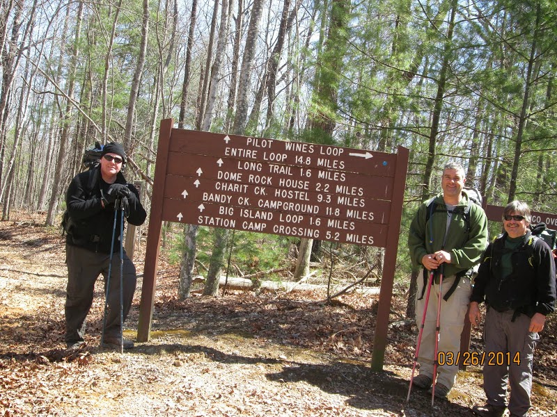
Pilot Wine Loop


Pilot Wine Loop: 14.8 miles                                              Outcasts Total Miles: 1659.68

We had us a weather full hike this time.  We headed to Big South Fork in the snow.  We started at the Station Camp East trailhead and did the loop counter clockwise.  This is a horse trail following an old roadbed all the way around.

Pilot Rock is actually just off the trail and you have to some bush whacking to get to it.  After you drop down through some very pretty rock walls and go around them there is a small campsite.  From that campsite if you continue straight out when the trails turns right and down you will find Pilot Rock.

We continued down to the river and camped along side the Puncheoncamp Fork of Williams Creek right at the confluence of Grassy Fork.

While we were hiking we had about five different white outs with sunshine in between.  When we got to camp, the snow was so big of flakes that you could feel them hit you.  We got about an inch on the ground before it stopped and we gathered fire wood during this time.  When it stopped, we set up camp and within a half hour the sun had melted it all away.  This is Tennessee.

Just before we got to camp we saw a flock of turkeys.  We had ducks on the creek and listened to an owl while we were setting up camp.

We enjoyed an evening around the fire telling lies and taking cough medicine.  It got down around 15 degrees that night.

The next morning we headed out and finished the loop with plenty of sunshine.  We saw a ground hog on the way out of the park cross the road in front of us.


                                                 Eye will see you next season!
Pictures:

Friday, March 14, 2014

Laurel / Snow Falls - Cumberland Trail


Day One: 9 miles                                               Outcasts Total Miles: 1644.88
Day Two: 4.9 miles

Total Miles: 13.9

Marco and I headed over to the the Laurel / Snow falls segment of the Cumberland Trail.  We hiked up Richland Creek and over the 50 foot bridge.  Then we headed towards Snow Falls which is a good climb after the 150 foot bridge.  We got some pics from the powerline overlook then did the ford of Morgan Creek.  Checked out Snow falls and then went back to the dirt road and hiked out to the Buzzard Point Overlook.  The dirt road does not have trail markers.  From the overlook we headed back down to the Henderson Creek Campsite for the night.

We saw our first two day hikers while we were setting up camp and they were coming back by while we were collecting firewood.  It was calling for 35 for a low, but we ended up with 24.  We stayed warm around the campfire enjoying the full moon and stars.

The next morning we hiked up to Laurel Creek Falls and then continued the climb which does get steep going up the bluff, to Laurel Creek Campsite.  We forded Laurel Creek and hiked out to the Overlooks. From Bryan Overlook there is a unnamed trail heading to two more overlooks past the four wheeler turnaround.  After that we headed back to the car.

Another great hike on the Cumberland trail.

Pictures:

Thursday, February 27, 2014

Mammoth Cave II


DAY ONE: 6.41                                      Outcast Total Miles: 1630.98
Pretrail: 1.25
Good Spring trail: 2.52
Collie Ridge trail: 0.53
Blair Spring Hollow trail: 1.6
Wet Prong trail: 0.51

DAY TWO: 8.4
Wet Prong trail: 3.01
Collie Ridge connector: 0.94
Good Spring trail: 2.02
Buffalo trail: 2.43
TOTAL MILES: 14.81

This is our second backpack at Mammoth Cave.  We started with our permit.  There was no one at the permit window, so we went down to the very last window to the only lady there.  We asked for the permit and she referred us to window number one.  I politely told her that no one was down there and she immediately told me that she would be down there in a minute.  So we walked down and waited patiently.

The lady came down and asked where we were going to stay. Back country site Raymer Hollow.  She said OK and she wanted the car description, tag, and a driver's license.  I told her the car description and looked up my picture of the tag on my phone which I proudly showed her.  She was not impressed as I had hoped and let me know that she needed my driver's license.  I told her the tag number and she told me she wanted my driver license first.  So I gave her my license and then had to look up my picture one more time.  Next she asked how we were going to get there.  I told her we were going to park at the Good Springs church and take the Raymer Hollow trail.  She told me the Raymer Hollow trail was closed.  I looked at the map and the only trail going to our campsite was that trail.  I said OK, then how can we get to that campsite? YOU CAN'T, IT'S CLOSED!  OK.  Pick another campsite (NOW)!  All the other campsites are available. That really surprised me.  Highs were going to be in the 20's lows in the teens and no body else was out camping? The pressure was on now, I was taking up her time and had to re plan our entire trip.  I looked at the map and slung out the next campsite I saw "Ferguson".  OK, how are you going to get there?  Ahhh, Marco start adding up miles!  I am waiting......I started sweating on the brow.....Well we will start at the church. YOU CANNOT PARK AT THE CHURCH!  Well yes I can, I parked there last time and took these trails.  YOU CANNOT PARK AT THE CHURCH AND THERE ARE NO TRAILS THERE!  Ahhhh, they were there last time.  THEY REMOVED THOSE TRAILS AND ADDED BIKE TRAILS SOMEWHERE ELSE!  Ahhhh OK, we will park at the Maple Springs trailhead and take this trail on your map.  YOU CANNOT TAKE THAT TRAIL!  YOU WILL ROAD WALK. Ahhhhhhh, OK! She printed off our permit.  You put this on the drivers side dash face down with this emblem pointed in this direction! Yes Mam.

Needing a drink very badly, we headed to her parking spot.  Deer were everywhere.  Not that they were used to people, but Troy had to get out and take the deer by the ear and walked them out of the road so we could drive on.  We got to the ferry and took it across the Green river.  We proceeded to the Maple Springs Trailhead parking.

OK, Marco had the brochure on back county camping.  I downloaded the map from the brochure on back county camping off the computer.  They are both different.  Even the miles for the length of the trails were different.  The map our dear lady had was different than both of ours.  Every time I had picked up her map she snatched it back out of my hands like it was the only one on the face of the earth.  Her map showed a trail from the parking spot that went up to the Good Springs trail. There on the kiosk was the only other copy of the map that she had.  It also had a notice on it that there are maps available at the trailheads and the information center.  Ya, right!  Anyways, we didn't road walk just to spite her.  We hiked the graveled trail to our trailhead.

As soon as we got on the trails, we were glad for cold weather.  These are all horse trails and dug up mud.  I would highly suggest you don't hike these trails in wet weather!  It did make it a little more challenging.  We did see more deer as we hiked and these deer, after watching you for a while, did run off.  The only water crossing we couldn't rock hop was Wet Prong which Troy built a bridge with an old log.

Marco was talking about his camping trailer and Troy was asking about the shower in it.  I explained that no one really uses the showers in campers.  Dad and Mom had one all of our growing up years and we never used it.  I was telling them about when we first moved to Florida and we were living in a guys cow field until we got a house to live in.  Each Saturday when we got a shower, Dad would hold a water hose out in the field and we would have to run under it, go get soaped up, and then run through it again.........Hey, now I know why it just feels normal when hiking to get a bar of soap in the creek.  Temperature never did make any difference to us.  Troy thinks I need counseling.

Anyways, we got to camp and got all set up.  We enjoyed an evening around the fire telling lies, listening to owls and taking cough medicine.  After Troy headed off to bed, Marco and I hung out a while.  I saw something run to the base of the tree that we hung our bear bag. It climbed up a ways and then peeked around the tree at me.  I pointed it out to Marco and he watched for it.  I just knew he was going to climb out on the limb with our bag.  Then he jumped out of the tree and flew to another.  It was a flying squirrel.  I didn't think they would be out at night.

I went to my hammock and climbed in.  After I got all settled in and got quiet, I heard snoring.  Marco was already tearing it up.  Now that was fast!  I was wondering if I was going to have to get up and put Marco the rest of the way in his hammock.  I could picture him standing next to it with his face on his pillow.

The next morning Marco had the fire going for us.  We had breakfast and packed up.  The mud was frozen as it had dropped down in the low numbers last night.

All the trails were well marked.  Some of them are roadbed and the terrain is rolling hills.  Another good hike.

Pictures:

Sunday, February 9, 2014

TTA Backpack North Chick Segment - Cumberland trail


Day one: 5.9                                                       Outcast Total:  1616.17 Miles
Montlake Rd to Stevenson's Branch campsite

Day two: 10.79
Stevenson's Branch campsite to parking 3.33
Parking to Montlake Rd. 7.46

Total Miles: 16.69

Murfreesboro TTA members Sara, Marco, Wayne, and I with Lora and Chuck from Soddy Daisy TTA, did an overnighter on the North Chickamauga Segment of the Cumberland Trail.  The young lady that picked this section from Memphis could not make it because she got "bit by a owl"?  Had "knee problems" or whatever reason, anyway we missed her company.

We met at the Montlake road trailhead and headed in taking the Hog skin lower loop after we got Chucks keys out of his car.  By the time we made it to the overlook past the stairs, we were ready for lunch.  The next section was old road bed that was covered with blow downs.  The real challenge starts at the cable crossing.

At the cable crossing, a tree was down in the middle of the creek on the cable.  Chuck went across first and whipped out a saw that would make a young girl blush.  He quickly cut limbs to make a safer crossing.  The cable is actually broke on the far side, being held in place by where the tree had grown around the cable.  It was a wet crossing for some and and an old fashion foot washing for the rest.

After the crossing there is another cable to help you get down to the ladder.  The cable came up and hit Marco's pack just right to completely empty one of his packs' pockets.  The stove and other contents went rolling down the hill.  The stand for his stove fell off the edge and was rescued by Chuck.

From the ladder down to Chickamauga creek was steep and slippery.  Everyone was excited to see the campsite and then quickly disappointed when I notified them that this was not the campsite we were staying at.  I think there was a competition between Sara and Wayne to see who could see the most worms as they both spent lots of time on the ground looking?

After we got to Stevenson's Branch campsite, we set up camp and collected firewood.  We spent a little time inspecting each others camping gear and then we sat around the campfire eating dinner.  The night was spent telling lies and taking cough medicine.

The next morning Wayne volunteered to watch camp while the rest of us did a day hike to the far end of the trail.  After a good old fashion foot washing in Stevenson's branch we did the switch backs up the side of the gorge.  We were very impressed with the trail work and design on this part of the trail.  Probably the best switch backs on the Cumberland trail.  We took a break at the overlook and then went to the parking area.

We got to see Panther Branch falls which had good water at it.  On the way back we stopped at the overlook again and ate our lunch.  We got back to camp where Wayne was glad we made it back.  We packed up and headed out.  Chuck went ahead and cleaned up a lot of the wind falls we had to climb over on the way in.  Sara and Wayne continued their competition as we went.  Marco got the award for the best fall as he was doing the cable crossing.  He got extra points for water coverage.  We saw a few hikers and trail runners on the way out.

Our wildlife consisted of a Bald Eagle and a mouse that ate Wayne's walking stick strap.

Great hike with some great people!

Pictures:

Friday, January 24, 2014

Big South Fork Cumberland Loop


Day One: 8.3                                           Outcast Total Miles: 1599.48
West Entrance Trail 3.4
297 Road 1.0
Trailhead 0.2
Gernt Trail 3.3
Overlook .4

Day Two: 14.1                                               
O&W Trail 5.5
Tar Kiln Trail 4.5
Darrow Ridge 3.2
Christian Cemetery 0.5
Panther Branch Trail 0.4

Day Three: 9.6
Panther Branch Trail 0.5
Little Cliff Trail 1.5
O&W Trail 5.2
Coyle Branch Trail 2.1
North White Oak 0.25

Day Four: 3.3
North White Oak Loop

Total Miles: 35.3

Once again the weather saw us coming.  It started snowing on our way to Big South Fork.  We kinda caught the ranger by surprise as he was not expecting any hikers today with the snow and 31 degree forecast.  Our high was supposed to be 31 this hike with a low of 4.  We were close as the high was 16 and the low was -5.

We got our permit and started at the Bandy Creek trailhead with a heavy snow falling.  We hiked to the West Entrance Trailhead on 297 and then did a road walk to the Cumberland Valley trailhead.  We had a couple of white outs on the way.  The West Entrance Trail is very beautiful.

We then hiked the Gernt Trail down to the Laurel Fork Overlook.  It was very nice with all the snow.  We continued our hike to the O&W trail along the North White Oak Creek.  We stopped at the Laurel Fork Ford to size it up for the next morning, then camped along side it on an old road bed.  We collect our wood, set up camp and enjoyed the evening.  The temp dropped to -4.

Day Two

Well, the Laurel Fork Ford had frozen over during the night so we had to break our way across it.  We did get some scratches from the thin ice and it took a little quarter mile walk to get the feet heated back up.  Not bad after the pain was gone.  The O&W trail is an old rail bed along the North White Oak Creek.  There was lots of icicles, frozen ground, and frozen water along the trail. We saw lots of fresh coyote tracks in the snow. Our next fording was of the Panther Branch Creek.  Not as much ice on this one.  Less pain.  We stopped and ate lunch along the side of the trail later in the afternoon.

At Tar Kiln trail we headed up and out of the river gorge and followed an old road bed through the woods.  It really would have been muddy if it was not frozen over.  There were lots of tracks in the snow.  Deer, cat, rabbit, and coyote tracks all through this area.  We got on the Darrow Ridge trail which is a dirt road and followed it to the Christian Cemetery Trail.  When we got on Panther Branch trail we started looking for the creek as the ranger had said it would be "difficult  to find."  Well much to our surprise, we found it under the first bridge we crossed. We got a laugh about it and then set up camp in the woods near by.  It was another good night by the fire as the temps dropped down to 7 degrees.

Day Three:

We did the ritual of thawing out water the next morning, packed up, and headed out.  We finished out Panther Branch and then took Little Cliff Trail back down into the river gorge to the O&W.  We though about going back and crossing the Panther Branch again just because that is what Outcast do, but just continued our trip.  The North White Oak Creek had frozen completely over in some places now and when we got to our Laurel Creek fording, it had frozen over too.

The ice was about an inch and a half thick.  Marco made it about halfway before he broke through and actually got back up on the ice part of the way across before breaking through again to finish the crossing.  I told Troy that we did not stand a chance, being as we both weigh more than Marco.  So it was in and out and in and out for us as we crossed as well.  Marco was the only one to get a good cut on his leg from the ice so we fared quite well.

Shortly there after we had a fording of the Groom Branch.  As I was putting my socks back on I told the guys, we probably need to wash our sock along with our feet at the next one. Then we got some miles in to warm up.  We stopped and ate lunch along the trail.  My tuna salad sandwich was frozen solid.  It still tasted good.  Today's high was 16 degrees and it got cool when the wind blew.

Our next fording was of Coyle Branch before we headed up out of the river gorge on the Coyle Branch trail.  This was all a very pretty part of the park.  The top part of the trail is road and we got off on the White Oak trail to find water for the night.

We found water on the Coyle Branch and made camp in a swampy, but frozen area.  We did have some problem with the wood being frozen and slow to burn, but we managed to stay warm as the temps dropped to -5.  We found that at a damp -5 we have to add clothes to our sleeping gear so that is our bag and hammock limit.  We listened to the owls talking that night.  It is difficult to go potty when you are shaking.

Day Four:

All of our hammock screens, tops of our sleeping bags, and underside of our tarps were frozen this morning.  Well, for that case if you stood around very long your breath started piling up at your feet.  We got a good hot fire going to thaw our water out to make breakfast.  We had 3.3 miles back to where we parked our cars and one fording of Bandy Creek.  Kept the long underwear on today.

After we got back, we stopped by the ranger station to let them know we were done.  The ranger asked if we really did all of our trail and we told him about our adventures.  He had been writing down the temps for us and said that we had "bragging rights."  We let him know we earned those along time ago.  A couple of other rangers came in and wanted to hear our story as well.  I don't know why they just can't believe someone would backpack in this weather.

Pictures:


Thursday, January 16, 2014

Hobbs Cabin IV - Savage Gulf

Day One: 8.2                                                                                    Outcast Total:1564.18
North Rim Trail to Hobb's Cabin                      
Day Two: 9.4
North Plateau Trail to Office  
Total Miles: 17.6 

Travis joined us again for another great hike.  This was his first time to Salvage Gulf.  The weather was cool to start with and then got cooler as we went.  Our wildlife viewing started at the beginning of the trail with deer and signs of where the wild turkeys had scratched.  There was plenty of water in the creeks and at Savage Falls.  

When we stopped for our first break and I dug through my pack for a snack, I found another bag of food that I did not pack.  I opened it to find a big bag of Troy's famous fried chicken.  Wow, what a great day it is!  After the appropriate hugs and "I love you's" the boys stepped back as I dug in.  Not a pretty site, but they knew how much I love that fried chicken.  Troy made enough for everyone and included cream corn, biscuits, and potatoes as well.

We had good views at the overlooks and started getting some big flakes of snow as we neared Hobb's cabin.  We passed a hornet nest that was just off the side of the trail.  We knew that good fire wood was hard to find at the cabin.  A very popular spot and unless you have a saw for all the large trees, small wood was gone.  We managed to scrape up a stack to last us through the night.  Travis got the fire going as we set up camp and soon we were sitting around the fire listening to owls as we got our chicken dinner warmed up.

After some lies and cough medicine we headed off to bed one at a time.  There were many owl calls during the night and a pack of coyotes doing some singing.  I woke one time to breaking of wood and Travis was out getting warmed by the fire.  The next time, Troy was packing the wood on.  We had a full moon so the woods was bright as the temps dropped below 15 degrees.  

When the moon finally went down and the sun came up, Marco had the fire going again.  We enjoyed an easy morning and then hit the trail.  On the way out we got to see some more deer.  Great hike as always here at Savage Gulf.


Pictures: